Freitag, 18. Mai 2012

May 18 - Jeju Island

After Hailey's complaint we had a really good sleep. Our alarm clock rang at 7:00, I got up at 7:30 and we had breakfast in the kitchen of our guest house. Hailey, who had gotten up earlier than me had already been grocery shopping and for the rest (bread) we went went to the in-house bakery.
(Our guest house was a really nice one but not good accessible. The taxi driver, who had driven us from the airport to the guest house had to call the guest house owner twice to ask for the way....:-)

our guest house: really nice but far away

in-house bakery

At 9:00 a.m. we took a taxi to the car rental station and picked up our car. Hailey was a little bit worried: she has a driver's license but doesn't drive very often. When she asked me to bring my international driver's license to Korea I was already in Japan, thus it was too late to pack it.

The first thing I learnt about Jeju Island was:
It is the only place in Korea where you can find palm trees:-)

palm trees at the roadside

Our first stop was Mount Hallasan (= World Natural Heritage) and Hailey had planned that we would go hiking:

There are several hiking trails on that mountain: The longest one takes about 8h and goes up to a pond on the peak of the mountain (= level 1). Hailey had chosen the level 2 hiking trail, that took us about 5 hours.

Trail information:
10:40 - 10:50 flat
10:50 - 12:00 uphill (2 short breaks included)
12:00 - 13:30 gradually up (1 break included), not steep, but very rocky trail.
13:30 - 14:15 instant noodle soup on the peak of our trail (1700 m above see level)
14:15 - 16:15 downhill on the other side of the mountain (down to 1280m above see level)
(=> uphill: Eorimok trail, downhill: Yeongsil Trail)

Information about the Eorimok trail that were taken from a pamphlet:
The Eorimok trail is located on the northwest side of Mt. Hallasan. After passing Eorimok valley, one hour's walk through the oak tree forest brings you to the widely open Sajebi Hill.
While you walk along the stony path over the Manse Hill, which rises 1,600m above sea level, a flatland comes into view. Another 30-minute walk will lead you to the Witseoreum Shelter facing the crater wall of the Baengnokdam Lake.
Information about the Yeongisl trail also taken from a pamphlet:
It is the shortest trail on the northwest of Mt Hallasan. Buses are available from the 1100 Road to the ticketing office that is located at 2.5km from the Yeongsil entrance. When you turn around the magnificent view of Obaeknahan and pass the colony of Korean fir trees, you will then approach Seonjakjiwat, an alpine meadow. In spring, Azaleas and Royal azaleas provide beautiful scenery.
In autumn, coloured leaves around fantastic rocks of Yeongsil Giam present a great sight.


Mount Hallasan
Mount Halla is famous for its dead trees and the Royal Azaleas in June. We were a little bit too early to experience the Azaleas in full blossom but it was beautiful anyway....

on the way to the starting point of our hiking trail: Eorimok
parking lot and starting point of the trail

information center at the parking lot

some information about our trail

flat part of the hiking trail

flat part of the trail

trail information (our trail: Eorimok to Witseoreum and back to Yeongsil)

uphill
after the uphill part

the gradually-up-part starts
lots of school classes were around
A funny experience was when we met all these school classes that were on a field trip. Almost every class had one or two students who said "how are you?" when they recognized me. When I answered: "I am fine, thanks and you?" they replied "I am fine too and have a nice day" or they even asked "where are you from?". Hailey was amused about that procedure and she told me, that this is the first English chapter in almost every English book.
This led me to the opinion that Korean people, especially the young generation, are much more talkative than Japanese people.
(Yuki told me later, that Japanese people are taught not to make any mistakes. Therefore they prefere not to speak English or to reply to a question only if they are 100% sure that their answer is correct. On the other hand Korean people just talk....)

sometimes the rocky trail was covered by a footbridge

on this "monorail" goods can be transported uphill or downhill
gradually up

Witseoreum

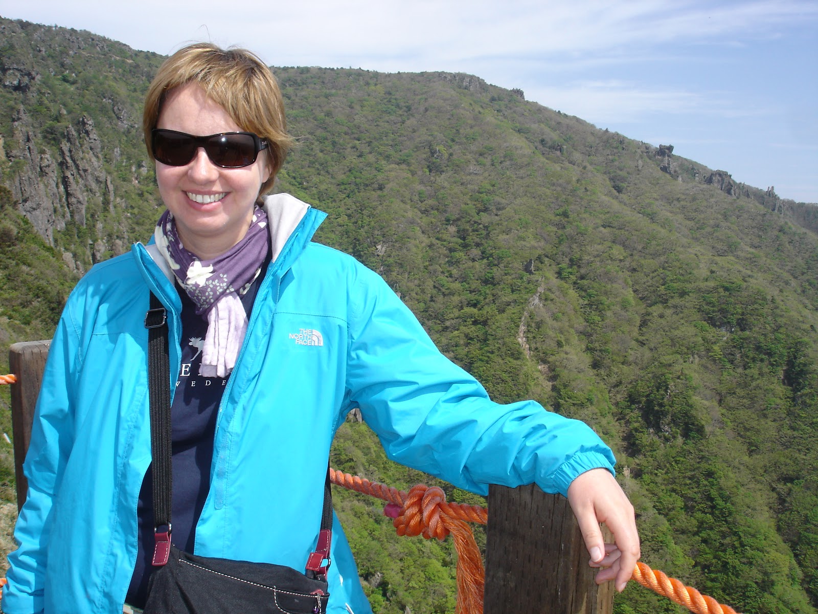
Hailey at Witseoreum

we made it:-)

lunch break (instant noodles => the taste had never been better)

1700m above sea level

how to use the monorail (water transportation)

on the way back (Yeongsil Trail)

art

Azalea fields that were about to blossom.
Facing the crater wall of the Baengnokdam Lake.

dead trees

the rocky way back
view to the oreums
Oreum is a word from the Jeju dialect that means "secondary volcanic cone". There are 368 oreums on Jeju Island, and each oreum has a crater of unique shape. When seen from Mt. Hallasan, oreum make for an otherwordly landscape.
more dead trees

again the view

a proof, that I was there:-)

more oreums

Yeongsilbawi Rocks

The Yeongsilbawi Rocks have been long considered the home of the Gods. These rocks are also called "Folding Screen Rocks" because they line up much like a traditional Korean folding screen.

Yeonsilgiam Rocks
Rocks, weathered by rain and wind for a long time are mysteriously lined up here to create the Yeonsilgiam Rocks.
According to a sad legend, 500 sons ate rice soup, unkown to them that it was made of their mother's body. After hearing the truth, they lamented endlessly and were so petrified with sadness that they turned into the rocks that we see today.
Today, these rocks are one of the 10 most scenic views on Jeju Island and along with the green forest in midsummer, make for a picturesque scene.
final point of our trail (1280m above see level):Yeongsil "entrance"

stone-widows at the parking lot

When we arrived at the final point of our trail Hailey found out that we had to walk for about another hour to reach the bus station (the bus that brought us back to our starting point). Because the two of us were tired we decided to take a taxi back to our car. But first we ate an ice cream:-) Then we took the taxi back to our car (about 15 minutes ride on the taxi) and reached our guest house at 17:20.

The guest house provided toilets and sinks but no shower. So every guest got a voucher that he or she could reedem at the hotel next to the guest house. This hotel had an Onsen and so Hailey and I went to the Onsen for about 1 hour. The Onsen consisted of several bathtubs (different temperatures). One was a special one: the water came directly out of the ground and on the way up it had cooled down to about 30°C. The water was supposed to be very good for your skin, so many women even put their face into the water. After a while resting motionless in the water lots of small bubbles stayed on my skin and created a comfy feeling on on it:-) I really think my skin was a little bit softer after that "treatment".

After the Onsen Hailey and I went back to our guest house, I put on a beauty mask and then we had a Korean barbecue in front of the guest house (19:30 - 20:30). One of the Korean guests of the guest house had lived several years in New Zealand and so we had a nice talk in English.

That night we slept in a big dormitory (thin walls, no doors, only curtains in the door frame). The lights were switched off automatically at 22:00 and so we went to bed early.


Donnerstag, 17. Mai 2012

May 17 - Seoul, Border, Jeju Island

I got up at 7 a.m. after another noisy night. One roomate had came late at night and switched on all the lights because she had found the right one, another roomate got up very early and didn't really try to be quiet, so it was another night with less sleep....But it was my last one at that YH...
I said goodbye to the YH at 8:50 when I was picked up for the JSA-Tour.

first top bed on the left was my own
The Panmunjeom or JSA (=Joint Security Area) tour was my birthday present from Hailey. I would spend the day with other tourists to visit the border between North and South Korea.

Panmunjeom Tour Regulations
"- You must carry your passport on tour day.
- When you arrive at the conference room, do not touch any equipment such as microphones or flags belonging to the communist side.
- Do not speak with, make any gesture torward or in any way, approach or respond to personnel from the other side. 
- Sometimes military or other official considerations prevent entry into the JSA.
- Casual clothes such as ripped jeans, sleeveless shirts, mini skirts, short pants, military clothes and sandals (slippers) are not permitted in the tour area.
- Shaggy or unkempt hair is not allowed either.
- Children under 10 years are not allowed.
- According to the military situation the tour can be cancelled without notice.
- According to the USFK regulation, there is a nationality limit. 
- If you cancel on the tour day, 100% tour fee will be charged."
And an additional interesting information might be, that South Korean people were not allowed to take part in the tour!

The guy who picked me up at the YH drove me (in a car) to the Lotte Hotel, from where our bus was supposed to leave. The tour started at 10:00 and I was seated next to Andrew from the UK who spoke English with a terrible accent that made me feel as a beginner of the English language:-(

1) Our first stop was the Observatory.

Dora Observatory
The following information are taken from the pamphlet we got:
Dora Observatory was built by the ministry of National Defense on September 8, 1986. You can view a North Korean village and the river that is the borderline. Also this place is the nearest point to North Korea from South Korea.

Our tour guide showed us around and then we had 10 minutes to ask a North Korean defector any questions we would like to. (we were asked not to take any pictures and publish them on the internet because the defector still has family in North Korea and she wanted to be unrecognized). The most shocking question and answer for me was:  "What would happen if you went back to North Korea?" and she replied "I would be executed in the public". 


Dora Observatory
in the entrance hall of the Observatory
the yellow line is the borderline, called MDL (= Military Demarcation Line)
North Korea's alcoholic liquors displayed in the Observatory building


Unfortunately it was raining, so I couldn't take any better pictures...
Our guide also explained us, that North Korea is much colder compared to South Korea, so many trees were cut off and the trunks were used for heating purpose. Thus it was "easy" to distinguish North from South Korea: North Korea was there were no trees were left.

the river is the border:
left side = South Korea, right side = North Korea

North Korean village in the background (unfortunately my camera wasn't good enought to take a better picture from the village in the distance)
We spent one hour (11:00 to 12:00) at the Observatory and a short movie about the North Korean situation was shown to us too.

2) Our second stop (from 12:15 to 12:45) was the Freedom Bridge, the destroyed train (only a 10 minutes drive away from the Observatory) and the Memorial Altar.

Freedom Bridge
Freedom Bridge is located 2 km north of Munsan, and it is the only path that connects the south and the north around Imjin river. It was originally the Kyung-eu railway bridge and reconstructed to a road bridge later.

Information about the Steam Locomotive

Steam Locomotive at Jangdan Station

information about Freedom Bridge

"entrance" to the bridge

Freedom Bridge

information about Memorial Altar

Memorial Altar

3) We ate lunch (Bulkoki with soy sauce, really delicious) from 12:50 to 13:50 before we were finally driven to the JSA.

our tour bus

restaurant where we ate lunch

4) Our last stop were inside the DMZ (14:30 to 16:00)

 Camp Bonifas, Panmunjeom, JSA

The borderline between North and South Korea is called MDL = Military Demarcation Line. The area around the MDL (5km's to the north and 5 km's to the south, about 155 miles in length ) is called DMZ = Demilitarized Zone. Panmunjeom is located inside the DMZ and it is the most forward location in the DMZ that can be visited by civilians. Although Panmunjeom is the common name of the area, the offical name of the negotiating site is the JSA = Joint Security Area. Panmunjeom is located in the western portion of the 155-mile long DMZ on the MDL. Panmunjeom is located 62 km northwest of Seoul, the capital of South Korea, and 215 km south of Pyongyang, the capital of North Korea.
Camp Bonifas is the base camp for the United Nations Command Security Force-Joint Security Area. It is located 400 m south of the southern boundary of the DMZ. This is home for the soldiers who support the Military Armistics Commission at JSA.

When we entered the DMZ our passports were checked twice on the bus. Then we were driven to Camp Bonifas, where
a) we could use the bathrooms
b) we had to sign a declaration paper
visitors declaration

c) we saw a slide show including a presentation about history and the current situation in Korea

From there we had to change the bus (from our tour bus to an UN bus) and were driven to the JSA.
The following information are taken from the pamphlet again:

JSA
The JSA resembles a square measuring about 800 m in diameter. After the Armistice Agreement was signed, the JSA became a neutral location where the guards from both sides were allowed to move around freely. It was the only place in the DMZ where the MDL was originally not cleary marked. That changed after North Korean guards murdered 2 UNC officers with axes on August 18, 1976. After the ax murder incident, the MDL was marked within the JSA, and that marking system continues until today. Today, the only place where border crossings are allowed is inside the conference buildings of the Military Armistice Commission (=MAC). The MDL in the JSA is marked with 126 1 meter-high white stakes along the borderline, that are posted in a 10 m interval. In the rest of the DMZ, the boundary is marked with MDL Markers. 
Each side owns 6 guard posts in the JSA and more than 35 armed guards can be present on each side. The JSA is a venue for exchanges and negotiations between the North and South. All kinds of political and economic issues, cultural conferences and Red Cross meetings are held in the JSA.

the conference building (unfortunately blurry:-(  )

the border runs through the middle of the table
South Korean soldier on the right side
the border between the conference buildings

South Korean soldier (standing with his right side in South and his left side in North Korea) and me (in South Korea)

our tour group and me (in North Korea)

our tour guide (wearing the yellow t-shirt)
conference buildings from the outside

United Nationa Command Military Armistice Commission (= UNCMAC)
Conference Building and South Korean Soldier

North Korean Soldier in the background


We were allowed to move freely into the conference building and take some pictures.

Note (especially for women:-) ):
My friend Hailey had told me that one job requirement for South Korean soldiers working at DMZ is to be very handsome because they need to be representative.
I can attest this:-)

On the way back to our bus we drove past the Bridge of No Return

Bridge of No Return

my visitor's tag

When we were back at Camp Bonifas we had time to buy some souvenirs in a souvenir shop (very touristic place for a military area...) and then we got on our bus and were back in Seoul at 17:20.

on the way back to Seoul:
Military Area is marked off by a wire fence
We were dropped off at Lotte Hotel and from there I took (according to my friend's instructions) a subway line to our meeting point. I met Hailey at 18:06 and then we continued our way to Gimpo Airport. We arrived at the airport at 18:30, had a fast Vietnamese dinner together (18:45 to 19:15) and flew to Jeju Island (air carrier "Asiana Airlines", flight number OZ8957, flight time: 19:45 to 21:00).
Our baggage was the last one on the baggage belt and due to the advanced time we took a taxi to our guest house.
Bedtime was at 23:00 but we couldn't sleep immediately because 2 guests were cooking, talking and watching TV in the adjacent room. After a while Hailey got up again and asked the guests to be more quiet. Then sleeping was no problem anymore.